Geometric models
Shareloc handles two type of geometric models: RPC and Direct location grids.
RPC
RPC is an analytic function for ground (lon,lat,h) to image (r,c) mapping.
It can be summarized as:

where:
 ,
,  are Rational Polynomial Function
and
 normalized ground positions.
The Rational Function Polynomial equation numerators and denominators are 20-term cubic polynomial functions, which respects RPC00B convention. This relationship between ground and image is called inverse RPC coefficients. Only inverse coefficients are compulsory, if direct ones are not available then direct localization is computed by iterating on inverse one
Direct mapping, if available can be summarized as:

where:
 ,
,  are Rational Polynomial Function
and
 normalized image coordinates (R,C) and normalized altitude H.
Further details are given in RPC in Geotiff, STDI-0002 2.1 (16Nov2000) specification document and Pléiades user guide Appendix C.3.
Supported RPC formats
DIMAP format (V1/V2/V3)
OSSIM keywordlist (.geom)
Geotiff RPC
All gdal supported format containing rpc (https://gdal.org/drivers/raster/index.html)
There is no standard format for RPC model. We recommend to use Geotiff RPC, which can be stored inside the .tif file as GDAL RPCCoefficientTag as described in the RPC in Geotiff.
RPC can be also stored in the .RPB file (with the same name of the image).
This second way is useful for expert users who wants to change RPC coefficients (scale and offset for example). A console script shareloc-rpcconverter is available to convert rpc formats.
See FAQ for examples
RPC class API Example
$ wget https://raw.githubusercontent.com/CNES/shareloc/tests/data/rpc/RPC_PHR1B_P_201709281038393_SEN_PRG_FC_178609-001.XML
$ python3
>>> from shareloc.geomodels import GeoModel
>>> file_dimap = "RPC_PHR1B_P_201709281038393_SEN_PRG_FC_178609-001.XML")
>>> rpc_dimap = GeoModel(file_dimap,  geomodel_type = "RPC")
Note : there is a C++ version of RPC geometric model (see Developer Manual.), which can be used by setting geomodel_type = "RPCoptim".
this geometric model is under development in current Shareloc version 0.2.13.dev14+g2f6ecbe9d.
Direct location grids
Direct location grid is a sampled geometric model, which contains direct location at each grid cell for H0 to Hn altitude layers.
It can be viewed at 3D grid (row,col,h) as illustrated below :
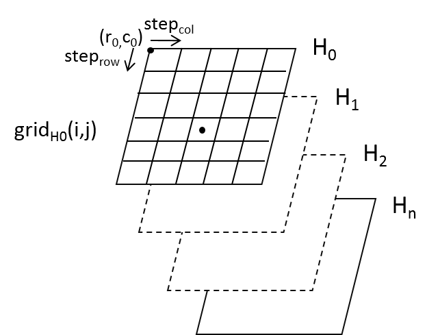
Fig. 1 direct location grid
Note
Within the grid a bilinear interpolation is used between the grid nodes. If a point location outside the grid is requested, shareloc computes an extrapolation that is equivalent to scipy.interpolation.interpn() function.
Shareloc grid format example
The example is composed of 9x5 grid composed of 3 altitude layers (-30m,485m,1000m). Each cell contains direct location at altitude layer of image position calculated from its geotransform.
In the example below:
my_multi_h_gridis a 9x5x6 grid.my_multi_h_gridcontains at index direct location of
  , for example with (band, row, col) convention
 ![my\_multi\_h\_grid[0:1,1,2] = direct\_loc(row = 1250,col = 625,h = -30)](data:image/png;base64,iVBORw0KGgoAAAANSUhEUgAAAlAAAAApBAMAAAAIfgpWAAAAMFBMVEX///8AAAAAAAAAAAAAAAAAAAAAAAAAAAAAAAAAAAAAAAAAAAAAAAAAAAAAAAAAAAAv3aB7AAAAD3RSTlMAi50Yz0h0MmD76d3zv6/wjZZjAAAACXBIWXMAAA7EAAAOxAGVKw4bAAAGY0lEQVRo3u1ZX2xTZRT/tXe993bd1sucSBiMjuAMILFKgmIiqxN8xJuoJEiwdyBDFPHGQMRo6I0xwOTfFp3wZgcRjQ/LwAQefGCJgfCiFkN4IRqmY+CfmSbLLDEm85zv9s/W3naXqoTEe5Km9zs9f3893/nO1wL/Ml3W3Mk1XavaxSO4y+m3VOF5w7iTROCcGXNrzVFwQ8ZZuOHrmTRvg6YZK0eBc9GqHdQaWA4cFM9qT/Gngt9NWaitN4s+el+339VP7Hf/2Jky6ZLZg9M5kh3vyQLHb80YKTtiJ8pA41mHeE6WavgWPlDQgJ1K1RSO4jSw2/5WSvIU/EWU/wuoNad98kbcBkq5f8Jm3EC75gyUP5a1n6dQRLxNKeDaGQMVjtiJ8u2HZmk8cNgNV3C5oCFopHqg6LueyEfr3IpOUf5n4E8VIZytqJz6edQPOQMVKjFr66pDBU6ni1AnbCeKQc8l8Uw1lmMN4vmChqD+6oEaQyC/4cKmo0iG8p8o2ZfFQPWiIe0MVKnZ9XYBT0n1rDug2IlIuySehlSJfJ2GKRrZVCqQr/Xhpme71iDwGuRUybpf/WVAW2d76V7XZKusmrVcvblnDpi/sKsHsUAGAbu2A0fLAEWVk3QCyt+2je0c3jdsQZ4dodfWw58P5wp4U4vOHFDWQoLWFFe9sdJ0BIqdKK0tViEeVpZbrzvthnBni5HXsGusr7PCobF7vSafxKtYEdRFb5iyrokQxiFNMvqE5M+6vUuUE1Kv/M61EeaHtJoYYioFZn8bylNlgUroOaAuryZam9u4q9nO1m+oA3ZgP57EWuJlK60+ovQIDm0cluD1ijo9qNdaJYZsRwldiuB8IR5W/g5v5cq2nhVW21NKIkU7NKdhl11f1vV0w1ky5sE3RB3ZiiOoF6+pgMOmqqSF5HHUGdmTMLO5O7qP+c0gNLmi1EzlrScaQOn35RtEB9mRH/tANcntDX8Sm7M7gI6guaTOHCUJIcFrK4EE/OUqSnSZq/l4WNmXpGAczrO4hnl5DbsJR3Chwt77gXM9zS0/XrRO8EHXnd/gGT4DiY5QA4iO2Ru/l9GNKROQx2cAqkFzAiqooY/sSOyi7kyjFdbyY8gIdxBpgjmBJIQEr4nfDJ9zjxJOgMX5eFiZXLTrDudZwsLr0ZxGrobHKwB1jHKVCP+LWFq0buatTS6CenbemSsEljB+PJcEdSXD6MZwC/IMzRyzHMfGhBlIs32qUrRTmSSi+TGkH2Tdl2aONCTqWKwpro6yQJETqvqH8vGwcsLEAqfzLGwwUDkNu4ap+soPIGmqHF/Sksa5jAprArdDDr+p90vGdjU7Rp2S+eF7wk9i6LerlOVSlfI/xdNQRaBUA5pDj4rDP2iR/XbKqF2sIdVqK0QB7yLrtRHmcDMnCbGmuC5iFxx7FDuhAepqPh5WjnPTyOwq6VHUkR8saNg1HNKMsj2KQGymrqkhrUxMX0vHdrf7cN6P333ZU2hcTIYvYYEpM/TE75EGfJT/gdyAV2jmVvb5FrCTUNi4f2/Kaevh8Wsa2XmFz2sdW+pM3Fen86EipTXqsU1gDk5ASPAaR6WP4DTR3bKd+KLSUREPu7fN+WJsrOTCMoTPChocYz/Cj5a/Avg1jEIdBVpa0picnMyv57+8Q2uYg01b8eJmhCcn/4pi1GCJhtmL4edciH+oa+M9lL/clr0y5MaDVc8M6IFeSnfkz+tYT1F+PDnpBJR6ZculKNlZyCCPdkb5JbeZ7IamgT2dmuCiDUKC1zg067nG0juZcCScNI6ZIh52b5uk7TXsAMDGZVZBg2P8Cg1dboZLf8rtGDri4q7LQ0z+ZP2nV9ud1SjJtyVtuL7+WkHTreyFOw1UKHr3AFWDS+4E/Uk56Q4oozjiqoFSUlUoGf8Nqr5Gl4blKy2400Bh790D1J34hTNVtQsFHnnk0f+WIh4E7ugJD4IZBoIO4N0WC7LmgVGJhhGOBJL4FEh6YFSiXxGMhQwsA92CPapI7VpY558w3/OgqExLEDcRjyLoQVGR5qdwxGSswh4Wlak5SigRVsGoh4UTHfiSiP/BCiUTOv/CXucBVYnWoH48bGEbvB5VkZQ/UJMOaVjkATUD/YSVEXWQB863PTAqkf/Hp4FNOyz7z0mPXNAXHgTuulXMw8AV1XvTgTu614PAHZkeBI70NwKV9xNtq8qLAAAAAElFTkSuQmCC)
$ gdalinfo my_multi_h_grid.tif
Driver: GTiff/GeoTIFF
Files: test2.tif
Size is 9, 5
Coordinate System is `'
Origin = (-312.500000000000000,-625.000000000000000)
Pixel Size = (625.000000000000000,1250.000000000000000)
Metadata:
  ALTITUDE_B0=-30.0
  ALTITUDE_B1=-30.0
  ALTITUDE_B2=485.0
  ALTITUDE_B3=485.0
  ALTITUDE_B4=1000.0
  ALTITUDE_B5=1000.0
  REF=EPSG:4326
Image Structure Metadata:
  INTERLEAVE=PIXEL
Corner Coordinates:
Upper Left  (    -312.500,    -625.000)
Lower Left  (    -312.500,    5625.000)
Upper Right (    5312.500,    -625.000)
Lower Right (    5312.500,    5625.000)
Center      (    2500.000,    2500.000)
Band 1 Block=9x5 Type=Float64, ColorInterp=Gray
Band 2 Block=9x5 Type=Float64, ColorInterp=Undefined
Band 3 Block=9x5 Type=Float64, ColorInterp=Undefined
Band 4 Block=9x5 Type=Float64, ColorInterp=Undefined
Band 5 Block=9x5 Type=Float64, ColorInterp=Undefined
Band 6 Block=9x5 Type=Float64, ColorInterp=Undefined
Grid API Example
$ wget https://raw.githubusercontent.com/CNES/shareloc/tests/data/ellipsoide/loc_direct_grid_PHR_2013072139303958CP.tif
$ python3
>>> from shareloc.geomodels import GeoModel
>>> geotiff_grid_path = "loc_direct_grid_PHR_2013072139303958CP.tif"
>>> geotiff_grid = GeoModel(geotiff_grid_path, "GRID")